 FAO Map Catalog
FAO - Aquaculture Management and Conservation Service (FIMA)
Type of resources
Available actions
Topics
Keywords
Contact for the resource
Provided by
Years
Representation types
Update frequencies
status
Scale
-
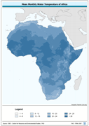
Predicted mean monthly water temperature (annual). Predictions based on air temperature estimates by the Center for resource and Enviornmental Studies (CRES) which can be interpreted as estimates of standard means for the period of 1920 to 1980 and mean annual wind velocity estimated by UNEP/GRID. The WATTMP_MN grid data layer is comprised of 1450x1380 derivative raster water temperature features derived based on 0.05 degrees resolution data originally from CRES/FAO. The layer provides nominal analytical/mapping at 1:20 000 000. Madagascar not included. The following layers are also vailable for download: Majority Monthly Water Temperature (Annual) Maximum Monthly Water Temperature (Annual) Median Monthly Water Temperature (Annual) Minimum Monthly Water Temperature (Annual) Minority Monthly Water Temperature (Annual) Range of Monthly Water Temperature (Annual) Monthly Water Temperature from January to December Acronyms and Abbreviations: CRES - Centre for Resource and Environmental Studies, The Australian National University (ANU); FAO - Food and Agriculture Organization of the United Nations; UNEP - United Nations Environment Programme
-
Consolidated table of water temperature. The WT_MNTHY tabular data layer is comprised of 1004351 derivative raster water temperature features derived based on 0.5 degrees resolution data originally from CRES/FAO. The layer provides nominal analytical/mapping at 1:220 000 000. Acronyms and Abbreviations: CRES - Centre for Resource and Environmental Studies, The Australian National University (ANU); FAO - Food and Agriculture Organization in the United Nations.
-

Seamless and topologically robust derivative of source DCW and VMap0 perennial/non-perennial SWBs from VMAP0-IW, DCW-DNNET and DCW-LCPOLY sources. The DNIW_HYD shapefile data layer is comprised of 25673 derivative vector surface water bodies features derived based on 1:1 000 000 data originally from DCW. The layer provides nominal analytical/mapping at 1:1 000 000. Seamlessly complete globally, with consolidation-harmonization @ ~70%, this Africa subset at final. Acronyms and Abbreviations: DCW - Digital Chart of the World; VMap0 - Vector Map for Level 0; SWBs - Surface Waterbodies; DNNET - Drainage Network layer; LCPOLY - Land Cover layer.
-
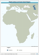
Seamless and topologically robust derivative of source VMap0 data layers for landmass and oceanic island data layers. The MASK_PY shapefile data layer is comprised of 2 derivative vector framework library features derived based on 1:1 000 000 data originally from VMap0, 5th Edition. The layer provides nominal analytical/mapping at 1:1 000 000. Data processing complete globally, this is an African subset. Acronyms and Abbreviations: VMap0 - Vector Map for Level 0.
-
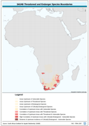
Threatened to endangered species watershed boundaries based SAIAB and HYDRO1k. Source: SAIAB and HYDRO1k, "river" flow, and watershed networks based on the GTopo30. The AQSP_THRTND_PY shapefile data layer is comprised of 92 derivative polygon aquatic species features derived based on 1:2 000 000 data originally from SAIAB. The layer provides nominal analytical/mapping at 1:2 000 000. Acronyms and Abbreviations: SAIAB - South African Institute for Aquatic Biodiversity; HYDRO1k - Global Hydrological 1 kilometre database of hydrologically filled DEMs; DEM - Digital Elevation Model; GT30/GTopo30 - Global Topographic 30 arc second DEM database, nominal 1km postings.
-
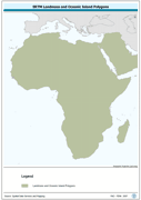
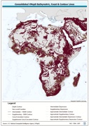
Seamless polygonal continental landmass and oceanic island mask data layer derived from SRTM-SWBD tiled database. The MASK_PY shapefile data layer is comprised of 4333 derivative vector surface water bodies features derived based on 1:100 000 data originally from SRTM-SWBD. The layer provides nominal analytical/mapping at 1:125 000. Data processing 60% complete globally, with African and Arabian subsets 100% complete. Acronyms and Abbreviations: SRTM - Shuttle Radar Topography Mission; SWBD - Surface water Body.
-
Consolidated Table of 7 Year Short Average Decadal Rainfall. The RFE_SAVG tabular data layer is comprised of 471688 derivative raster precipitation features derived based on 8 kilometers data originally from EDC. The layer provides nominal analytical/mapping at 1:3 500 000. Acronyms and Abbreviations: EDC - USGS EROS (Earth Resources Observation Systems) Data Center.
-
Vectorized CRES 3-by-3 Minute Point Reference. The CRES_PT shapefile data layer is comprised of 1004351 derivative calculated water temperature features derived based on 0.5 degrees resolution data originally from CRES/FAO. The layer provides nominal analytical/mapping at 1:220 000 000. Acronyms and Abbreviations: CRES - Centre for Resource and Environmental Studies, The Australian National University (ANU).
-
Consolidated Table of CRU Evapotranspiration. The ET_MNTHY tabular data layer is comprised of 92717 derivative raster evapotranspiration features derived based on 0.16667_ data originally from CRU. The layer provides nominal analytical/mapping at 1:70 000 000. Acronyms and Abbreviations: CRU - Climatic Research Unit - School of Environmental Sciences, University of East Anglia - Norwich.
-
Seamless and topologically robust derivative of all linear VMap0 - Ed3 bathymetric, coastline, and terrain contour data layers. The HYPSO_LN shapefile data layer is comprised of 108715 derivative vector framework library features derived based on 1:1 000 000 data originally from VMap0 | 5th Edition. The layer provides nominal analytical/mapping at 1:1 000 000. Data processing 75% complete globally, with African subset 100% complete. Acronyms and Abbreviations: VMap0 - Vector Map for Level 0.